I am inspired by many things. Last week, I met up with a friend (and fellow writer) for
tea and before going our separate ways, we took a wander through Chapters.
Chapters is one of the banes of my pocketbook. My pocketbook has a few enemies,
namely clothes, makeup and the Sims. But, Chapters is an extremely dangerous
place for me. I buy something every time I step foot inside one. I try to avoid
it, but I do have my moments of weakness. But, despite the store being the bane
of my pocketbook, I always emerge from it happy because I have something new.
At the end of my last trip, I came out with a collection of maps from the A Song of Ice and Fire series by George
R.R. Martin.

 |
|
There are twelve maps included in the collection
|
I love maps. Maps tell us stories about our history, where
we came from and where we are going. Mapmaking is thought to have begun around
600 BCE in Babylon.
 |
| A Babylonian Map |
The map above depicts Babylon on the Euphrates river,
surrounded by a circular landmass showing Assyria, Uratu and several cities,
all surrounded by a “bitter river” (the ocean). Seven islands are arranged form
a seven-pointed star. Accompanying text mentions seven outer regions beyond the
bitter river. Five of these regions have survived. Island number three is where “the
winged bird ends not his flight”. Island number four is where “the light is
brighter than that of sunset or stars (it lay in the northwest and was in
semi-obscurity after sunset in summer). The fifth island was due north and in
complete darkness “where one sees nothing” and “the sun is not visible”. The
sixth island was where “a horned bull dwells and attacks the newcomer”, and the
seventh island was in the east and was “where the morning dawns”.
Around 500 BCE, this world would expand to include much of
Europe, parts of Asia, and northern Africa, then all known as Libya.
 |
| The World according to Anaximander c. 500 BCE |
As Alexander the Great campaigned in the east, maps began to depict
Asia more accurately. But these maps and maps such as the mappa mundi (plural:
mappae mundi), were not used as navigational aids. Instead, they were used for
informational purposes, to tell people what lay beyond the borders of their
lands. These maps consisted of what was then the known world; Europe, North
Africa, and Asia. In many of these maps China has yet to be fully mapped and India
appears as an island rather than connected to Asia.
 |
| Ptolemy's World Map c. 150 AD |
Some cartographers believed that the earth was flat, and
there were maps that reflected this. Some claimed that ships would simply drop
off the edge of the world if they journeyed past certain points. Many more had
the words, “Here be monsters” on the oceans because, let’s face it, the oceans
were and still are mysterious and dangerous.
In 1389, the map below was printed on silk and positioned
China in the centre with Europe half way around the globe and very small. Also
shown was Africa’s Cape of Good Hope area, an area not yet visited by the Europeans.
 |
| Da Ming Hun Yi Tu's world map, 1389 |
In 1492, the Erdapfel (German: earth apple) was created by
Martin Behaim and is considered the oldest surviving terrestrial globe. The
Americas were not included because Christopher Columbus did not return to Spain
until 1493.
 |
| Oldest surviving globe |
After 1500, the Americas would be included on world maps,
though primitively, because they had yet to be fully explored. But, the
Americas would be explored and thus, the maps would get better.
Included in my collection of maps is the Historical Atlas of
Toronto by Derek Hayes. Inside it is a history of Toronto told through cartography.
Would you believe that the map below was one of the first survey
maps ever made of the Toronto area?
 |
| It was included in a 1793 letter to Britain from Lieutenant
Governor of Upper Canada, John Graves Simcoe. At this time, Toronto was called Dublin. |
The letter D is in reference to the implemented street plan.
The letter C is the barracks used by the Queen’s Rangers; those barracks are
now Fort York. The double line below the numbered lots is Lot Street; Lot Street is now Queen
Street. I want to bring your attention to the rivers that are in this map. Of
those rivers, only one still exists. The Don River, the river on the far right,
is the only of those rivers still here. All the others have been covered or
converted to sewers.
Does anyone know where Toronto got its name? The 1675 map
below should give you a clue.
 |
| note Lac de Taronto |
Taronto is an anglicized version of the Iroquois word, ‘tkaronto’,
meaning, “place where trees standing the water” and referred to the northern
end of what is now Lake Simcoe. In 1834, legislature decided to name the city,
which had been called York, it’s original name of Toronto.
The city grew quickly. This bird’s-eye view is from 1884.

Compare that with this satellite image from 2000 that
includes the entire Greater Toronto Area (GTA) from Hamilton in the west (left)
to about Bownmanville in the east (right):
 |
| Colours: Purple - developed areas; Green - parks; Light Green - farmland; Red: Fallow land |
Without maps, we would never know what the places we call
home looked like 20, 30, 50, or 100 years ago.
But there is another reason I love maps. I love them because
they can introduce us to the worlds of our favourite books. As well as owning a
collection of A Song of Ice and Fire
maps, I also own a collection of Middle-Earth maps.
Included, are four maps; Beleriand, Middle-Earth, Numenor
and the Wilderland. When I look at the map of Middle Earth, I see pieces of our
own world in there. I see the west coast of Europe if Great Britain were physically
connected to France (as it once was many, many, many, years ago).

Now, I see absolutely nothing wrong with this. I also see
nothing wrong with the shapes of George R.R. Martin’s maps in his A Song of Ice and Fire series.
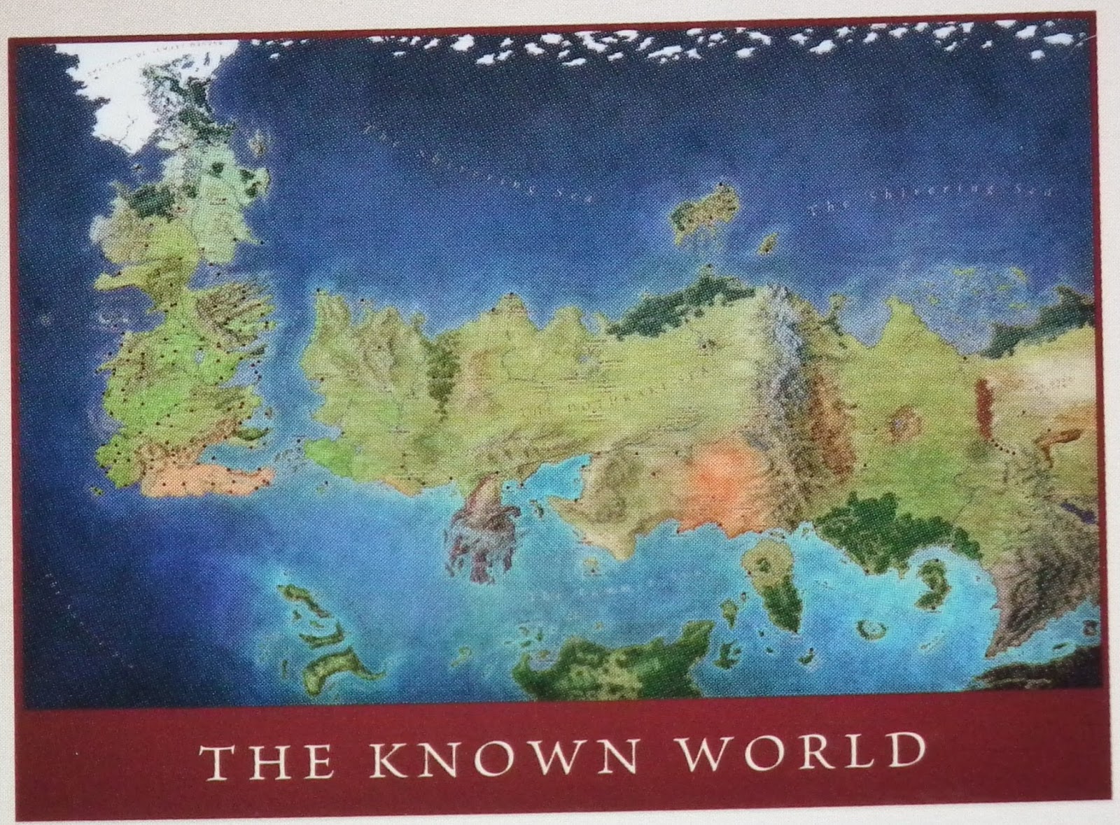
When you look at the above map, what do you see? I won’t
tell you what I see; I’ll let you think about instead.
I’ve used maps, as well as many other things, as inspiration for my Pangaea Trilogy. The map
of Pangaea is based on the supercontinent that once existed on our own earth. I
added two islands to the world; Coburg Isle and Allegheny. Allegheny was inspired
by the eponymous region of the United States. I am still working on a map for
Coburg Isle. Due to the lack of copyright for said maps, they have not been
included in this blog.
I am not ashamed to say that my Pangaea maps have been
inspired and based on real places on Earth. Now, I am, by no means, a
cartographer, so my maps are far from perfect. I long for the genius minds of
J.R.R. Tolkien and George R.R. Martin when it comes to mapmaking, but I’ll have
to settle for what I have.
Maps have inspired Man since Man created them. They have
allowed us to explore new worlds, all of them real. Many may not believe the
worlds of Martin and Tolkien are real, but they are real to the men who created
them. The world within my Pangaea Trilogy is as real as any world. It is where
my characters dwell and it becomes my home every time I write more in the
trilogy.
Maps are beautiful. They are windows into the past; they are
platforms for the present and pathways into the future. They allow us to learn
and to ask questions. And learning is a beautiful thing.
I think it's great that you're so interested in maps. (I think Pangaea definitely showcases your attention to detail!) I'm glad that you're enjoying these :)
ReplyDelete